.jpg)
工作坊:无人机与参数化工具用于建筑遗产测绘与分析
Workshop:UAV and Parametric tools for Surveying and Analyzing Architectural Heritage
.gif)
❶
PART I
介绍
近年来,消费级无人机与摄影测量软件的结合使大尺度建筑遗产三维数据的采集越来越便捷,提供了地面测量与空天遥感之间一种中等尺度的测量方式。工作坊针对从事建筑遗产保护、既有建筑改造的建筑师、研究者、学生,包括从图像采集到点云生成、再到运用参数化工具与GIS分析点云模型的全过程,涉及从建筑单体到建筑群、古村落、古镇等不同尺度的建筑遗产,旨在通过3天的培训使参与者初步掌握利用无人机、摄影测量、参数化工具数字化记录与分析建筑遗产的方法。
▼
❷
PART II
内容
6月9日
6月10日
6月11日
-
如何用Grasshopper进行大尺度建成环境的可达性分析、视线分析
-
介绍:Grasshopper在建成环境分析中的运用
-
实践:使用Grasshopper模拟建成环境的太阳辐射(基于无人机摄影测量实例)
-
工作坊总结与展示
▼
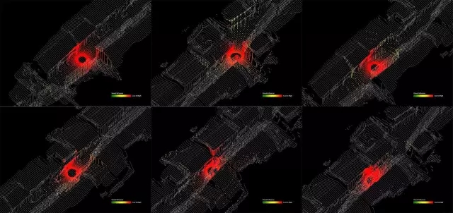
从点云模型生成剖面
❸
PART III
教师
曹永康,上海交通大学建筑遗产保护国际研究中心主任,上海交通大学建筑系副教授,威尼斯建筑大学访问学者。
IgnacioLopez-Buson(楼纳修) 和Mary Polites(玛丽普莱蒂斯),AA硕士,研究方向为景观城市主义&新兴技术&设计。 2014年他们与陈都一起创立MAPS图斯,希望通过对不同尺度设计的创新性研究, 探寻适宜人与自然的共处空间策略。他们在AA、AA上海研习班、新加坡科技设计大学、同济大学、土人学社具有丰富的教学经验,涉及景观、城市主义、设计技术等。最近,他们致力于探究无人机与参数化工具在分析与评估中国古村落中的潜力。
孙政,南京工业大学建筑学院讲师,博洛尼亚大学博士,研究方向为遥感与摄影测量在建筑遗产测绘与分析中的应用。从2014年开始研究无人机摄影测量,在上海、南京、西藏等地的建筑遗产测绘中积累了丰富的经验。
▼

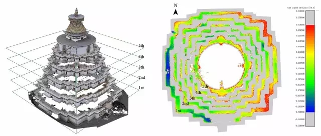
建筑群尺度无人机摄影测量及建筑构件区分
❹
PART IV
时间:
2017年6月9日-6月11日
地点
上海交通大学建筑文化遗产保护国际研究中心(上海交通大学徐汇校区)
▼
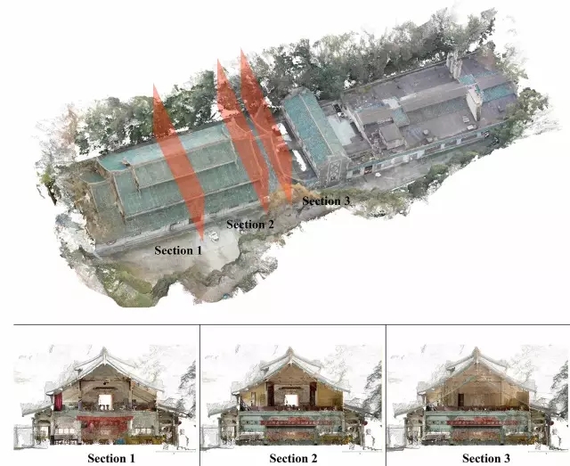
建筑正射图生成
❺
PART Ⅴ
软件
需提前安装PhotoScan(30天试用版),Cloudcompare, Rhino (Grasshopper, Ladybug, Honeybee)
费用与证书
1800元/人,培训技术后将获得由主办单位提供的证书
▼
无人机摄影测量用于景观数据的叠加
❻
PART Ⅵ
主办单位
上海交通大学建筑文化遗产保护国际研究中心
MAPS图斯
中国文物保护技术协会建筑遗产保护教育中心
联系人与报名方式
孙政 18114469982,sunzheng@njtech.edu.cn
请将个人信息(姓名、单位/学校、联系方式)发送至上述邮箱
▼
古村落数字高程模型
▼
古村落视线分析
▼

古村落太阳辐射分析
❶
PART I
Introduction
UnmannedAerial Vehicles (UAVs) are one of the latest pieces of technology to becomeavailable for designers with the ability to capture and digitize spatial reality.With the democratization of such technologies, architects and urban plannersare starting to unveil the hidden diversity of the physical environment, thanksto the flexibility and the increment of accuracy and resolution that dronesprovide in comparison to other remote sensing technologies.
This workshopproposes a design methodology for theanalysis, evaluation and design of architecture that merges together GIStechniques, environmental analysis and algorithmic design by means of threedimensional modelling generated by photogrammetric techniques applied toobjects, buildings and urban environments. In opposition to the idea of usingdata for just optimization and efficiency , the aim is to understand howdrones, cameras and 3d scanners are able to capture reality through pointclouds, and how the processing and visualization of this information couldexpand the ambition and challenge the boundaries of architectural designdisciplines.
Content
9thJun.
-
Significance of digital technologies inarchitectural heritage conservation
-
Introduction of digital measurement forarchitectural heritage: laser scanning and photogrammetry
-
Practice of photogrammetry with SLR andUAV
-
Operation of PhotoScan and Cloudcomparefrom images to point clouds, mesh and orthoimage for mapping and analyzing ofsingle building
10thJun.
-
Computational Design and Datavisualization in Architecture (short lecture)
-
Introduction to 3d modeling softwareRhinoceros 3d (interface, visualization, import point clouds and meshes)
-
Introduction to algorithmic designsoftware Grasshopper
-
Introduction on how to analyze mesh modelswith Grasshopper (dimensions, heights,etc.)
11thJun.
-
Introduction on how to perform urbananalysis with Grasshopper (GIS principles) (proximity, visual accessibility,etc.)
-
Introduction on how to run environmentalanalysis with Grasshopper
-
Practice of using Grasshopper to run solarradiation simulations
-
Workshop summary,work presentation
-
❸
PART III
Lecturers
Cao Yongkang
Headof International Research Center for Architectural Heritage Conservation andassociate professor of department of architecture at Shanghai Jiao TongUniversity, visiting professor of IUAV, Italy.
IgnacioLopez-Buson and Mary Polites
IgnacioLopez-Buson and Mary Polites hold master´s degrees in Landscape Urbanism andEmergent Technologies and Design from the London Architectural Association. In2014 they formed MAPS (Methods for the Architecture of Patterns and Systems) withtheir colleague Du Chen, to start a research, teaching and design initiative inShanghai. MAPS primary focus is to analyze the complexity of current social,economic and natural systems and articulate their logics into diverse andlivable environments in China. They have teaching experience related tolandscape, urbanism, and design technologies in international schools such as theLondon-based Architectural Association (AA), Shanghai AA Visiting SchoolProgram, the Singapore University of Technology and Design (SUTD), TongjiUniversity in Shanghai, and Turenscape Academy in Huangshan.
Due to theircurrent research in rural planning in China, they have started experimentingwith the potential combination of UAV and computational design in the analysisand evaluation of Chinese heritage villages.
Zheng Sun
Lecturer atSchool of Architecture, Nanjing Tech University, PhD of Bologna University.Research field: remote sensing and photogrammetry for architectural heritagesurveying and analysis. Since 2014 he has been engaging in employing UAV-Photogrammetyfor architectural heritage surveying and analysis in Shanghai, Nanjing andTibet.
❹
PART IV
Date
9th-11th June,2017
Location
InternationalResearch Center for Architectural Heritage Conservation, Xuhui Campus ofShanghai Jiao Tong University
❺
PART Ⅴ
Software requirement
PhotoScan(30days trial), Cloudcompare, Rhino (Grasshopper, Ladybug, Honeybee)
Fee and certificate
1800RMB/person.Certificate granted by host
❻
PART Ⅵ
Host
InternationalResearch Center for Architectural Heritage Conservation, Shanghai Jiao TongUniversity
MAPS
EducationCenter of Conservation Technology for Architectural Heritage, National RelicConservation Association
Contact and registration
ZhengSun 18114469982, sunzheng@njtech.edu.cn
Sendinformation (name, affiliation, contact) to emails above
(审读、编辑:汤超)
